
- Home
- About Us
- Stories
- Categories
- Technology & Innovation
- Eye in the Sky

Technology & Innovation
Imagine standing on the edge of a vast oil palm plantation, where a sea of trees stretches as far as the eye can see. Beyond the immediate vicinity, the landscape becomes a blur, making it nearly impossible to notice what’s happening in the distance. Yet, when a fire ignites, every second counts, and delays can devastate both the livelihoods of planters and the biodiversity of the surrounding environment. This is why Wilmar uses satellite monitoring - a vigilant eye in the sky that enables us to respond swiftly to any emergency situations.
The primary situations being monitored are deforestation incidents and fire outbreaks. Through advanced satellite monitoring systems, we monitor large areas efficiently and can detect these events without relying on manual on-site outposts. This system is synchronised with our on-the-ground teams as well as the local authorities, ensuring that prompt actions are taken whenever a crisis develops. Today, we utilise satellite imagery to proactively oversee 23.4 million hectares of land across our global operations and supply base, including conservation areas.
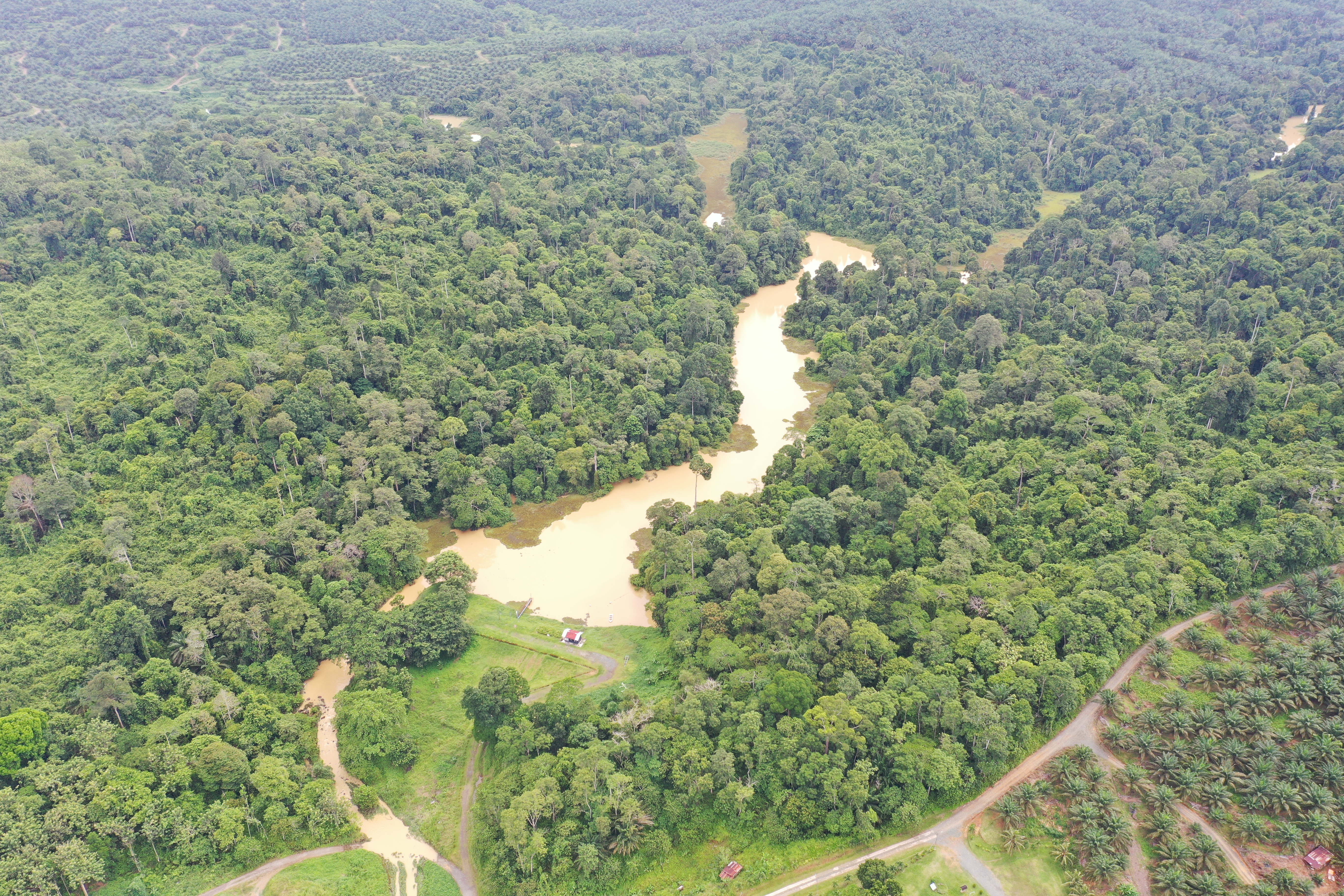
We use satellite monitoring to assess the ecosystem health of our Reka Halus conservation area in Sabah, Malaysia.
How satellite monitoring works
Satellite monitoring works by using specially equipped satellites orbiting the Earth to capture images and data about the land below. We engage satellite monitoring vendors to closely track large-scale areas and identify instances of deforestation, while simultaneously extracting National Aeronautics and Space Administration’s (NASA) broader satellite data to locate fire hotspots.
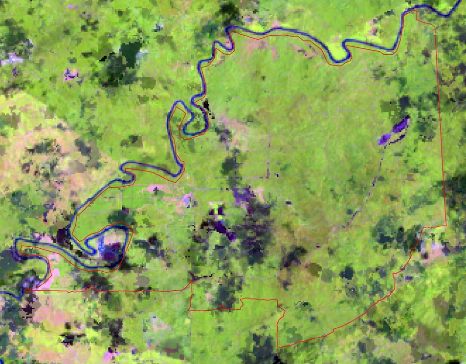
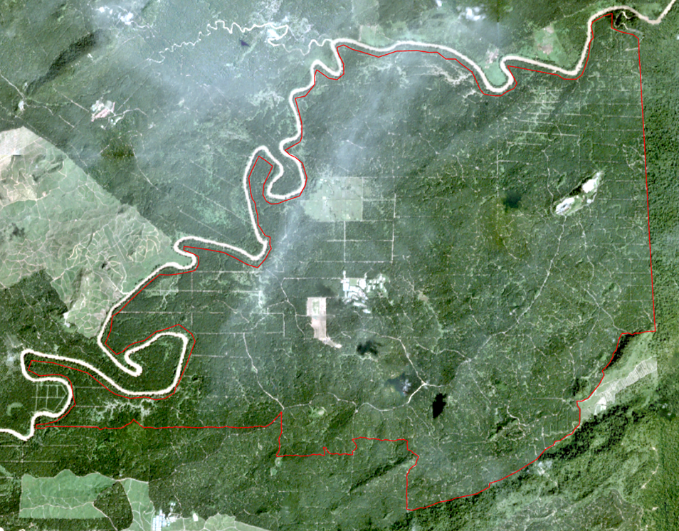
Each satellite vendor employs unique algorithms to identify anomalies in monitored areas. These algorithms are designed to detect events such as tree removal or unusual heat patterns that could indicate a fire. Once these situations are detected, the data is delivered to us in the form of geospatial shapefiles, which are digital maps pinpointing the precise locations of these changes on the plantation.
Using infrared technology and a combination of sources
One of the most important features of satellite technology is its ability to see beyond what’s visible. Satellites equipped with infrared sensors can capture data about heat and vegetation that goes unnoticed by ordinary cameras. This is especially useful in detecting forest fires even through smoke or darkness.
The challenge, however, is dealing with cloud cover. Regions like Malaysia and Indonesia which have tropical climates experience frequent rainfall and dense clouds. These can obscure satellite imagery, making it harder to capture clear images. As such, we use a combination of satellite images from different satellite imaging companies such as Sentinel, Landsat, and Planet that have varying resolutions and capture images at different intervals. By stitching these images together, we can gain a clearer view of the land despite cloud cover and create a historical time-series which are a set of data that tracks changes over time.
Satellite images of varying resolutions from Sentinel, Landsat, and Planet (ordered from left) of our Sabahmas estate (oil palm plantation) in Malaysia.
Validating data and taking action
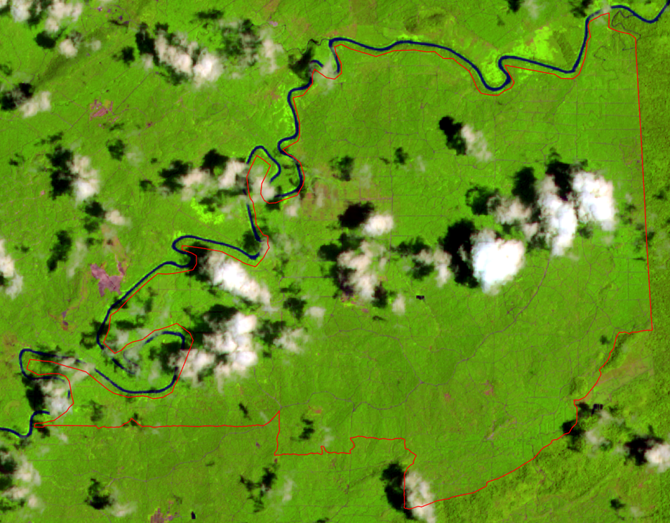
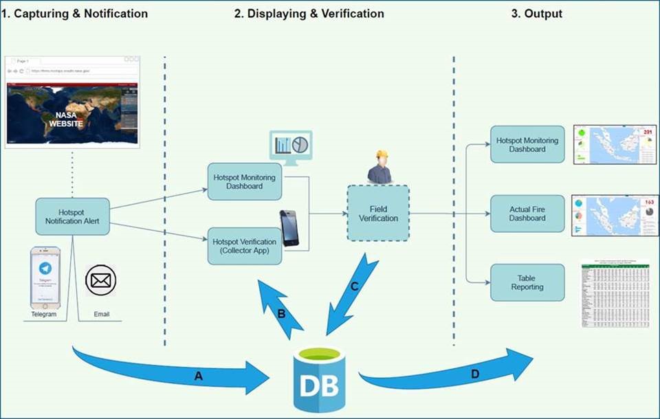
DB: Wilmar's database.
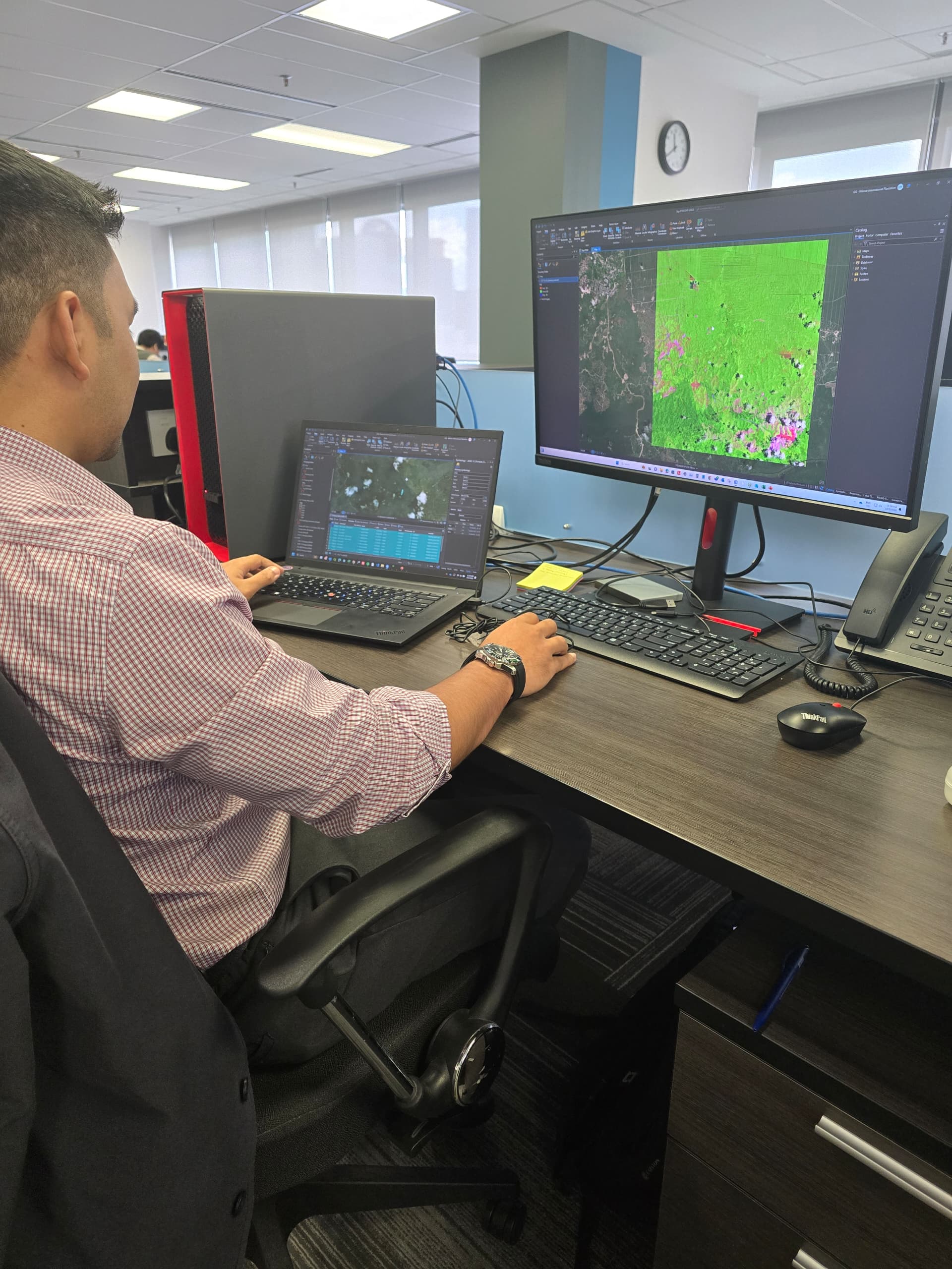
We employ a round-the-clock fire and deforestation monitoring system that uses satellite imagery to detect fires within and up to five kilometres outside their boundaries.
In situations where satellite data detects a fire hotspot, urgency is key, and an automated alert is sent directly to the person-in-charge of the estate. A ground team is swiftly deployed to verify the fire alert, and their findings are shared with the Geographic Information Systems (GIS) team. Once the hotspot is confirmed, our fire-fighting teams and the estate’s fire brigade are immediately activated to manage the situation. Local authorities will also be alerted in certain events.
In situations where a deforestation alert is triggered and sent to our GIS team, the team leverages advanced software tools such as ArcGIS Pro, ArcMap, and QGIS to rigorously analyse and verify the data.
They also cross-reference the satellite imagery with other open-source platforms to rule out false positives, such as replanting of oil palm and flooding, ensuring the alert’s accuracy before notifying the ground team.
Long-term monitoring and preparedness
Satellite monitoring is not just about reacting to problems as they happen. It also helps us to anticipate and effectively prepare for various situations. By continuously collecting satellite data, we can track patterns over time and identify areas that are prone to recurring fires. This long-term analysis gives us valuable insights into trends and helps us take proactive and preventive measures, such as clearing dry vegetation and equipping local communities with fire retardant equipment.